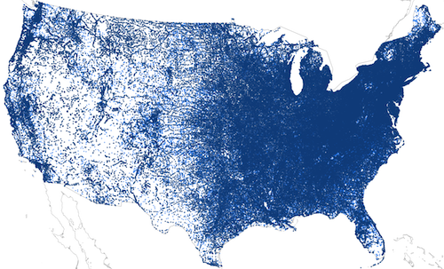
US Post Offices is a spatial-historical dataset containing records for 166,140 post offices that operated in the United States between 1639 and 2000. The dataset provides a year-by-year snapshot of the national postal system over multiple centuries, making it one of the most fine-grained and expansive datasets currently available for studying the historical geography of the United States:
 US Post Offices in the Contiguous United States, 1789-2000. Darker points represent exact locations and lighter points are randomly located within their surrounding county.
- Read the data biography detailing how the dataset was created and how it should be used.
- Download the full dataset at Harvard Dataverse
- The code that was used to process and geocode the historical records can be found in the project’s Github repository.
- The following publications provide more information about the historical geography of the US postal system and make use of this dataset:
- Cameron Blevins, Paper Trails: The US Post and the Making of the American West (New York: Oxford University Press, 2021).
- Cameron Blevins, Yan Wu, and Steven Braun, “Gossamer Network” (2021).
Credits and Citations
- Richard W. Helbock (1938-2011) conducted the archival research to compile information about historical post offices.
- Cameron Blevins processed Helbock’s data into a spatial-historical dataset and made it available online.
If you use the dataset, please cite the Harvard Dataverse record:
For more information about this dataset, contact Cameron Blevins.
