Transit Time (Days)
▼Click a city on the map or search above to see its transit times to all destinations.
Transit times for railway mail service between major U.S. cities, 1882–1908
Click a city on the map or search above to see its transit times to all destinations.
In January of 1882, a letter mailed from New York City to San Francisco would take nearly a full week to travel across the country. By 1902, that same journey had been cut to a little more than four days. This map uses a series of tables published by the U.S. Post Office Department recording how many hours it took for mail to travel via railway between 12 major railroad depots and roughly 120-130 cities across the country in the late 1800s and early 1900s. Mapping these transit time tables shows the distances separating Americans in different parts of the country and how the US Post and an expanding national railway system connected them.
Mail transit times were computed by the U.S. Post Office Department using railroad schedules, and reflect ideal conditions - ie. no delays or missed connections. They also capture only one leg of the journey: the time spent moving between railroad stations, not the additional time required to get a piece of mail to and from a depot on either end. The actual time between dropping off a letter at a post office and arriving in the hands of its recipient would therefore be
This project was completed in early 2026 by Cameron Blevins over several steps. First, mail transit time tables were located in a selection of United States Postal Guides found on HathiTrust and then downloaded as separate PDF files.
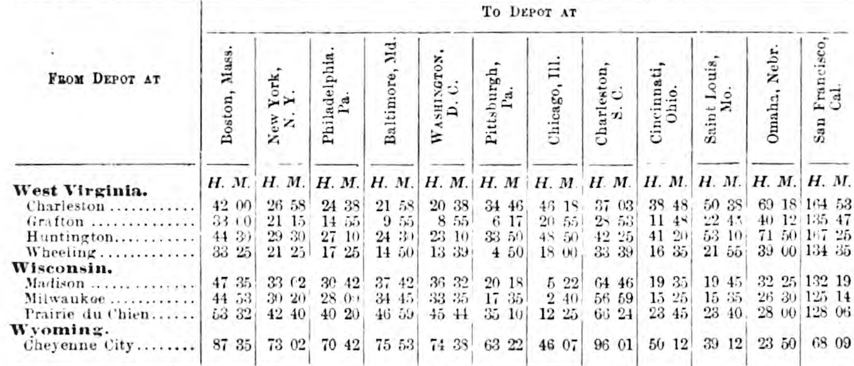
Excerpt of transit time table from 1883 U.S. Official Postal Guide
The remaining steps relied extensively on Generative AI tools: Google's Gemini 3.1 Pro was used to extract data from each transit table PDF and process it into a CSV file. Claude Code (Sonnet 4.6) was used to combine yearly data into a single dataset, then identify and fix potential transcription errors (ex. a value of 33:15 recorded as 83:15). Finally, Claude Code (Opus 4.6 and Sonnet 4.6) was used to build, design, and deploy the visualization.
This data was transcribed from the following sources:
The full dataset of mail transit times can be downloaded as a CSV file.
All railroad data comes from: Jeremy Atack, "Historical Geographic Information Systems (GIS) database of U.S. Railroads for 1826-1911" (May 2016; revised Oct 31, 2023).
Mail had been traveling by railroad in the United States since the 1830s, but the real breakthrough came with the creation of the Railway Mail Service in 1864, when the Post Office Department began sorting letters aboard moving trains. By the 1880s and 1890s, these railroad postal routes had become the backbone of the world's most expansive postal system.
Cameron Blevins, “How Fast Was the Mail?” 2026, https://cblevins.github.io/mail-time/.